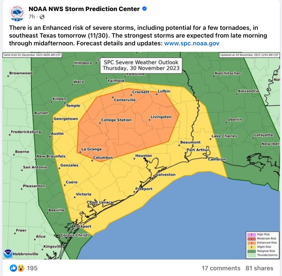
Strong storms possible Thursday in the Houston area
Tonight
Look for winds to kick up tonight, especially at the coast, where they could gust to 30 mph or so by morning. Scattered showers will spread north and east through the night, arriving in the Matagorda Bay area by midnight and across the rest of the metro area by morning on Thursday. Temperatures will only drop back a few degrees overnight, into the low-60s or so. They should even climb some toward morning.
Thursday
In a couple of words: The worst of the weather tomorrow should occur from about 8 AM to 4 PM, with strong to locally severe thunderstorms, capable of producing strong winds, hail, and isolated tornadoes, as well as heavy rain.
We will have a couple of things to watch for on Thursday. First and foremost, strong to severe thunderstorms may begin to break out across the area as early as the back half of the commute, after 8 AM or so. The atmosphere looks fairly primed to produce storms with strong winds, potentially some hail, and even a tornado or two around the region. This doesn't look quite as foreboding as what we experienced almost a year ago back in January with the Pasadena tornado (which was an exceptional setup for severe weather here), but the parameters are definitely aligned for at least some severe weather.
More technically: There's a pretty healthy amount of wind shear (wind changing direction with height) available tomorrow. You need wind shear for severe weather and tornado risk. But the window for that severe weather and tornado risk tomorrow looks conditional and narrow. In other words, we need the appropriate amount of instability to realize to generate thunderstorms. And on top of that, we need the storms to be able to tap into that shear and instability at low levels. This is not a slam-dunk case for severe weather, but it's enough to say that if storms can realize their full potential tomorrow there could be a couple of tornadoes, especially north of I-10. We should have a better idea on this tomorrow and will have more for you before it gets messy out there.
In terms of rainfall, we are not expecting significant or widespread flooding. But street flooding is a decent possibility in a few spots tomorrow. Most areas will see a half inch to inch or so of rainfall, but a couple of isolated spots will almost certainly see 2 to 3 inches of rain or even a bit more, much of which could fall quickly.
All this should start to clear off to our east by late afternoon and evening, leaving us with clouds and a few showers. Temperatures and humidity will build up tomorrow, with highs near 70, and you'll feel the dampness.
Friday
The forecast gets a bit trickier on Friday. The storms of Thursday will be well off to our east as a cold front slips into the region. However, it looks as if this front may stall near the coast or just offshore. This would keep us generally a bit cloudy and unsettled with shower chances, depending on exactly where it stalls. Temperatures will be mainly in the 60s, with 70s will be possible near the coast on Friday. The exact placement of the front will determine how warm it is on Friday.
Weekend into next week
That front may backpedal onshore Saturday, bringing more clouds and showers. Morning lows will range from the 50s inland to 60s near or south of the front. By Sunday, the stalled front should be escorted out into the Gulf by a second cold front which will usher in cooler, drier air and hopefully some sunshine for early next week. Admittedly, I'm skeptical about much clearing right now but we're still several days out.
Texans tailgating looks okay right now, with temperatures probably in the 50s to low-60s most of the morning, warming into the mid-60s or so for the afternoon. I'm not going to completely rule out a shower, but I would lean toward drier weather at the moment.