

Northwestern Gulf of America:
Northwestern Gulf of America:

Joined:
X days ago
# Posts:
X,XXX
Contributor Points:
X
Northwestern Gulf of America:
A trough of low pressure located over northeastern Mexico is
producing disorganized shower and thunderstorm activity.
Development is not expected during the next day or so while the
trough remains inland and drifts northward over northeastern Mexico
or southern Texas. The system is then forecast to move northeastward
and could re-emerge over the northwestern Gulf of America late
Tuesday or Wednesday, where environmental conditions may support
some development around midweek. Regardless of formation chances,
heavy rainfall and flash flooding are possible across portions of
eastern and southern Texas and Louisiana this week.
* Formation chance through 48 hours...low...near 0 percent.
* Formation chance through 7 days...low...30 percent. 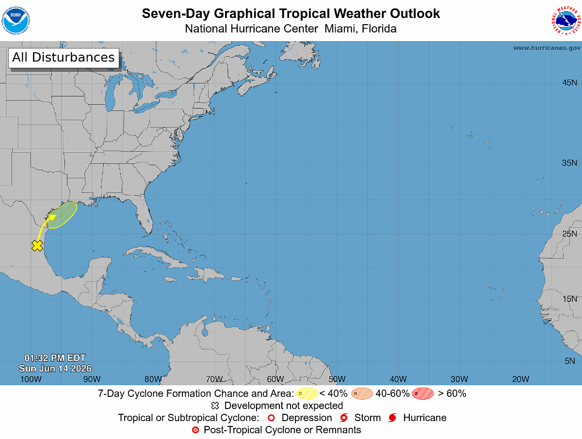


TexasGal, ladybeachbum and KathyMarshall + 4 more reacted A trough of low pressure located over northeastern Mexico is
producing disorganized shower and thunderstorm activity.
Development is not expected during the next day or so while the
trough remains inland and drifts northward over northeastern Mexico
or southern Texas. The system is then forecast to move northeastward
and could re-emerge over the northwestern Gulf of America late
Tuesday or Wednesday, where environmental conditions may support
some development around midweek. Regardless of formation chances,
heavy rainfall and flash flooding are possible across portions of
eastern and southern Texas and Louisiana this week.
* Formation chance through 48 hours...low...near 0 percent.
* Formation chance through 7 days...low...30 percent.
Replies:
National Weather Service has already issued a Flood Watch for our area.
eighteen, KathyMarshall and Reese + 4 more reacted National Weather Service has already issued a Flood Watch for our area. #msg2186769
I just moved 7 of my Squash plants that were in the "unprotected" garden area to an area under my patio where they won't get drenched for the next few days....One of the nice things about a "container garden" is that it's "portable"..... I did the same thing with other plants during severe storms and Hurricanes we've had in the past.....Never lost one....
TexasGal, Mutton and eighteen + 6 more reacted
I have been in Galveston for six days and we stayed out on west beach, and we left to come home yesterday, and the tide was in and the water was up to the road had never got up that high any of the other days something may be brewing.
TortieMama and KathyMarshall reacted
@Smokeybear :
We got hammered with rain at my house around 7 last night. It was the 3rd heavy rain storm we had yesterday but it was the most intense.
RajunCajun and KathyMarshall reacted We got hammered with rain at my house around 7 last night. It was the 3rd heavy rain storm we had yesterday but it was the most intense.
Andi7: Do your chickens mind the rain? Or do they not care? #msg2186885
@Andi7: Yeah. I get it. When my feathers get drenched I get a little funny myself! LOL!
TortieMama, Mutton and Andi7 reacted 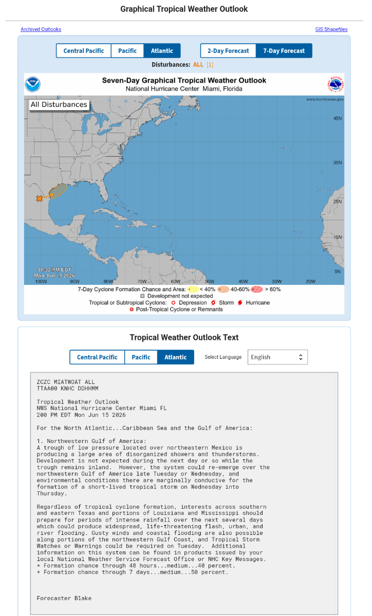

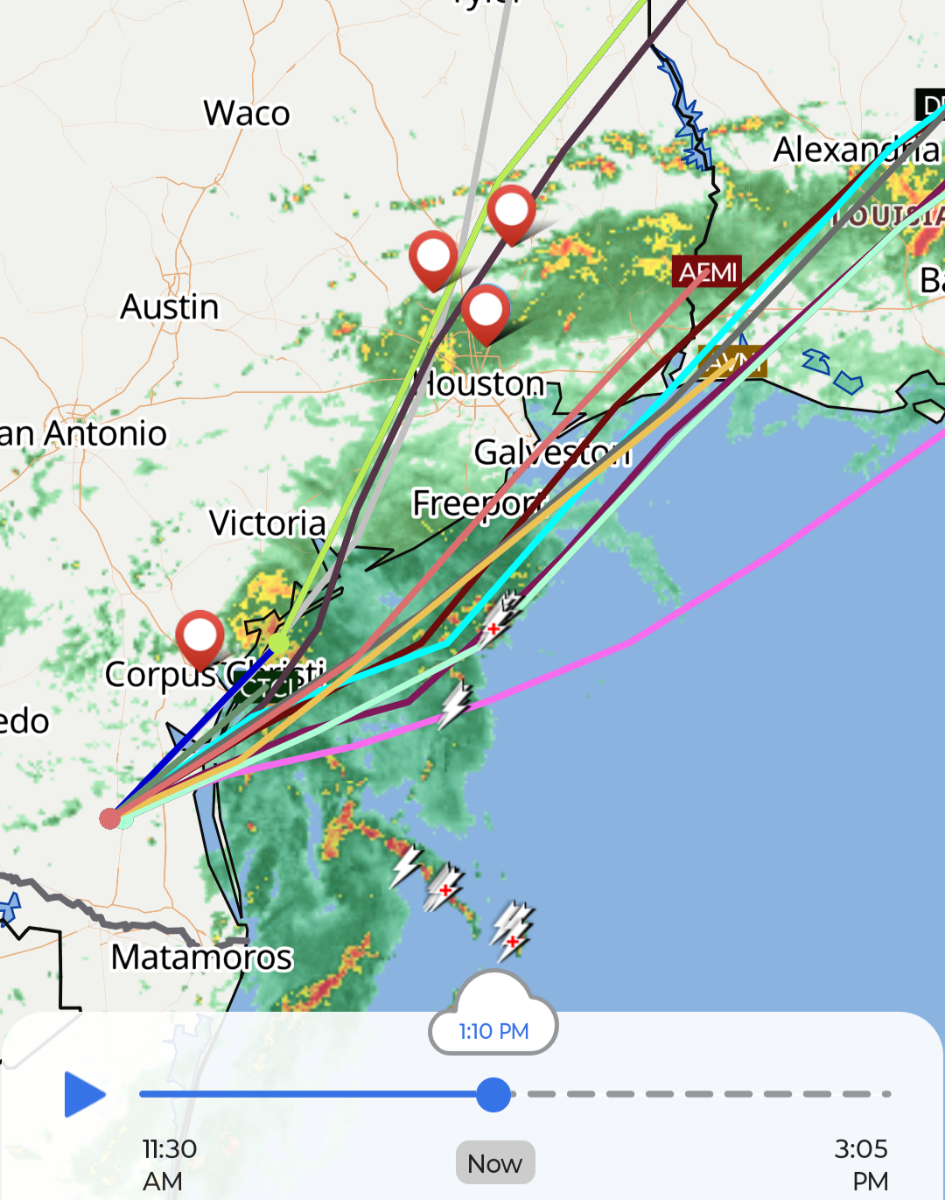
As of this morning, a low-pressure system located over South Texas is starting to move toward the Gulf. On Wednesday, it should move to the northeast, just off the Texas coast, toward Louisiana. At this time it may have a brief period during which it can spin up into a tropical depression, or possibly a named storm (it would be called Arthur). The National Hurricane predicts there is a 60 percent chance this occurs. Although certainly there would be a lot of noise around a tropical storm forming in the Gulf so close to Texas, we're here to tell you the impacts from this system are going to be similar regardless of its development in the coming days. And there's some good news in the forecast. Remember how we've been talking about the boom or bust potential later this week, on Wednesday and Thursday, due to heavy rains from this tropical system? As of Tuesday morning we are leaning toward bust. Put another way, after today and this evening, our rain chances will probably trend down somewhat. And we think the likelihood of very heavy rainfall (i.e. bullseyes of 10 inches or above on Wednesday and Thursday) in the Houston metro area is low. It's not zero yet, but things are trending in the right direction. There will be some winds and tides to contend with, but nothing too significant. More on that below. Tuesday
In terms of heavy rainfall, conditions will be most favorable today across the Houston region with rich tropical moisture spreading into the area. There is a thick band of heavy rainfall offshore the Texas coast this morning, spreading all the way from Corpus Christi to Port Arthur. The key word there is offshore. Some of this activity is spreading inland this morning, and we expect rains to move into the Houston area today. Due to the tropical nature of this airmass, rainfall rates could be quite high, quickly leading to street flooding (and hence, our Stage 2 flood alert). 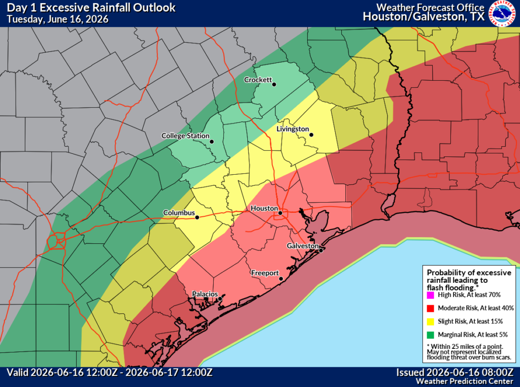
Rain accumulations today should be highest along and to the south of Interstate 10. In these locations 2 to 4 inches of rain will be possible, with some isolated areas of 6 inches possible. Further north totals should be less. Due to the rain-cooled air mass temperatures today for most locations should be in the 80s, with lower 80s likely near the coast. Rain chances should slacken somewhat overnight, but there will still be pockets of activity.
Wednesday
The aforementioned tropical system should pass closest to Houston on Wednesday. At this time we think it will track southeast of our region, remaining off the coast. In this case it should keep the heaviest rains offshore. The major risk at this time is if the system tracks more to the north, and moves inland into the Upper Texas coast. This would mean more rain over the Houston metro area. To be clear, we don't think this will happen, but we are watching for this possibility and will of course keep you informed. Anyway, our best-guess forecast at this time for Wednesday is for about a 60 percent chance of rain showers, with better chances and higher accumulations closer to the coast. For now rain totals look fairly manageable, with 1 to 2 inches, but again this would change if the tropical system took a more northerly route. We are also likely to see some coastal wind gusts of about 30 mph, starting early Wednesday morning. I'm not sure how far inland these will extend, but it's possible they could reach areas such as Pearland or League City. (Again this is dependent on the tropical system's track). Water levels will also be 1 to 3 feet above normal tide levels, so there could be some minor coastal flooding. High temperatures on Wednesday should be in the upper 80s.
-June 16, 2026 at 6:57 am by Eric Berger
In terms of heavy rainfall, conditions will be most favorable today across the Houston region with rich tropical moisture spreading into the area. There is a thick band of heavy rainfall offshore the Texas coast this morning, spreading all the way from Corpus Christi to Port Arthur. The key word there is offshore. Some of this activity is spreading inland this morning, and we expect rains to move into the Houston area today. Due to the tropical nature of this airmass, rainfall rates could be quite high, quickly leading to street flooding (and hence, our Stage 2 flood alert).
Rain accumulations today should be highest along and to the south of Interstate 10. In these locations 2 to 4 inches of rain will be possible, with some isolated areas of 6 inches possible. Further north totals should be less. Due to the rain-cooled air mass temperatures today for most locations should be in the 80s, with lower 80s likely near the coast. Rain chances should slacken somewhat overnight, but there will still be pockets of activity.
Wednesday
The aforementioned tropical system should pass closest to Houston on Wednesday. At this time we think it will track southeast of our region, remaining off the coast. In this case it should keep the heaviest rains offshore. The major risk at this time is if the system tracks more to the north, and moves inland into the Upper Texas coast. This would mean more rain over the Houston metro area. To be clear, we don't think this will happen, but we are watching for this possibility and will of course keep you informed.
-June 16, 2026 at 6:57 am by Eric Berger
@Smokeybear : I am lowering my pool right now. Better to be ready because it is close to the house.
Smokeybear and Andi7 reacted ** Would you be interested in keeping up to date with news & events going on in the Atascocita area? Consider supporting an alternative social media platform for Atascocita by creating an account today! (it's fast, easy, privacy focused, and free!)
« Back to Chat
Views: 275
# Replies: 20
