


Why Texas faces a growing flood threat this week
Why Texas faces a growing flood threat this week


Joined:
X days ago
# Posts:
X,XXX
Contributor Points:
X


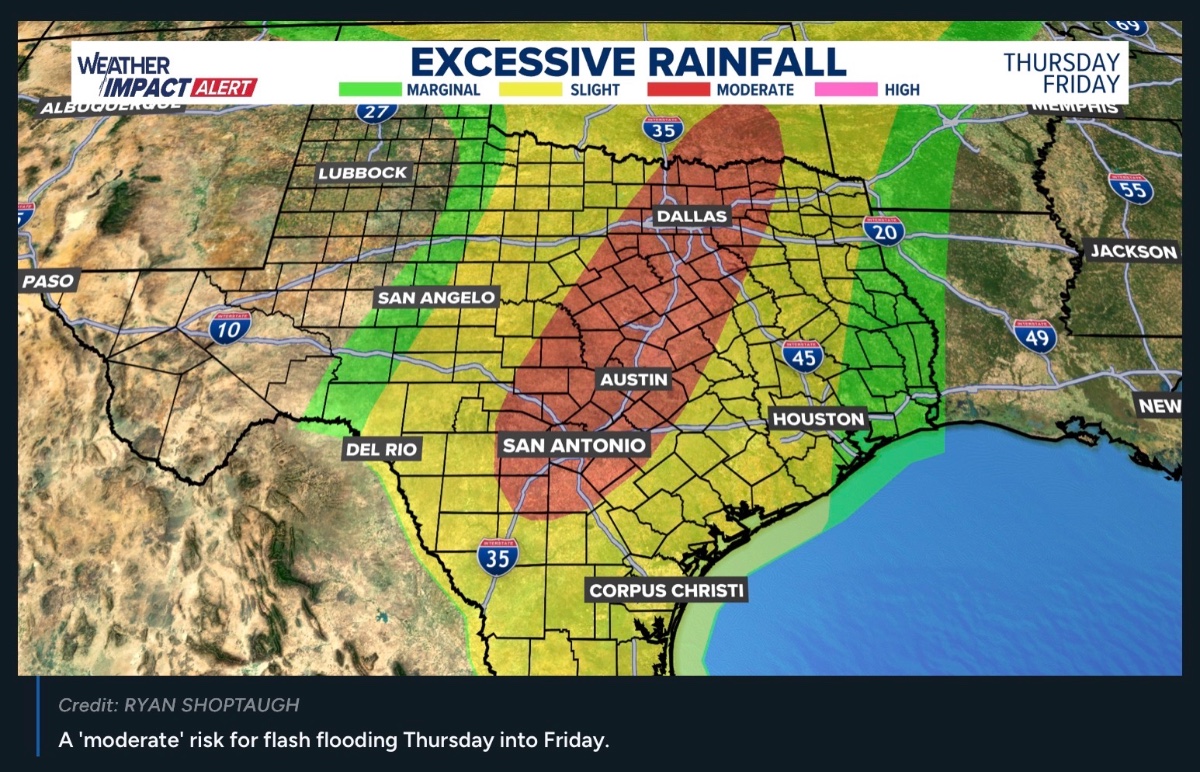
Why Texas faces a growing flood threat this week AUSTIN, Texas - Flood watches are already in effect for parts of Far West Texas, where the threat of locally heavy rain begin this week. Based on the latest forecast guidance, this trend will likely prompt additional flood watches across the state later this week. Rain chances increase across North and Central Texas, Wednesday evening. The greatest flash flooding risk will range from I-35 into the Texas Hill Country. Forecasters say the timing and placement of a stalled cold front will determine which areas see larger amounts of accumulated rainfall.
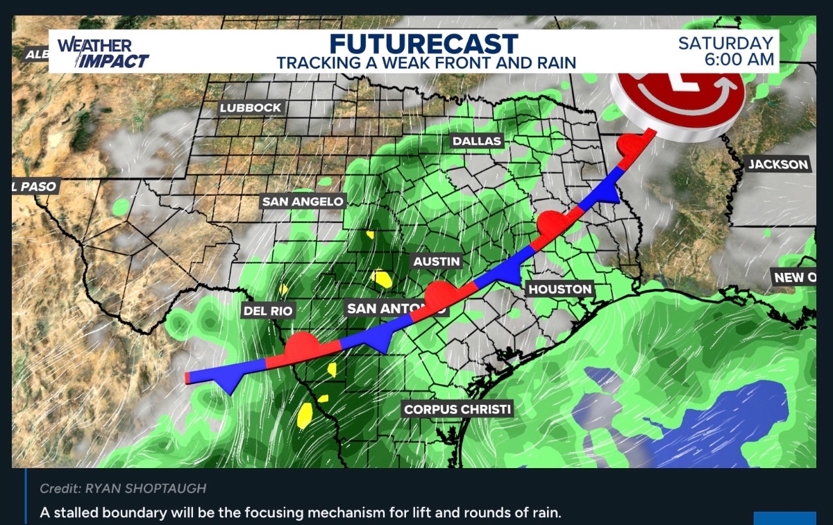 This setup brings together moisture from two directions. An approaching Pacific storm system is expected to draw moisture associated with Hurricane Polo northeastward, while southerly winds carry moisture inland from the Gulf. A Pacific cold front could then focus storms into bands that pass over the same communities repeatedly. Polo's hurricane winds are NOT the forecast threat in Texas; the concern is how much rain its moisture could help produce. The average will be 2-5" on average across several regions of the state with locally higher amounts.
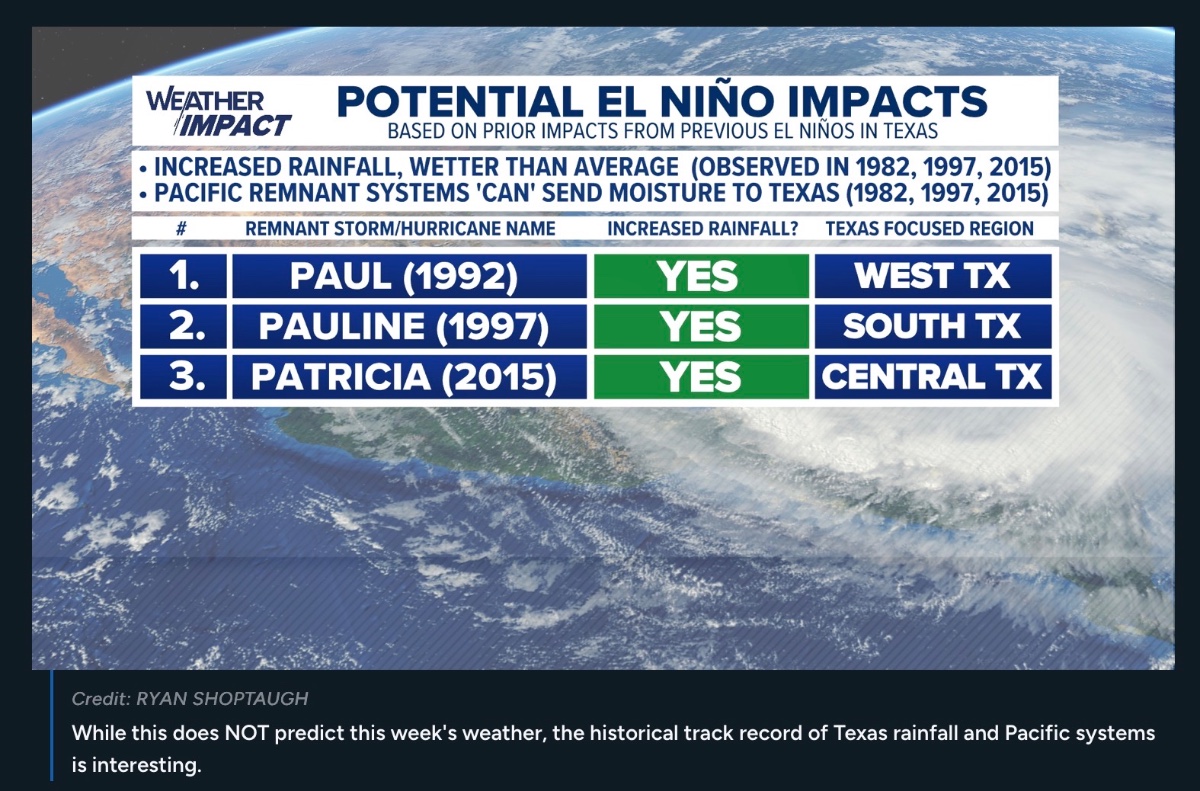
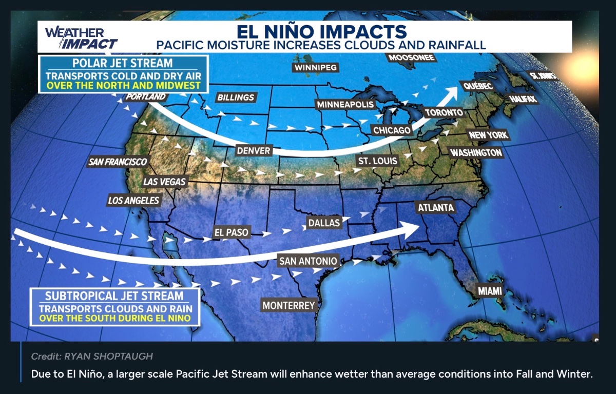
Texas has seen this kind of fall flood setup before, though no past event predicts this week's outcome. In October 1997, moisture associated with Hurricane Pauline contributed to flooding in the Rio Grande Valley during an El Niño. In October 2015, the remnants of Hurricane Patricia interacted with another system, helping produce 5-12 inches of rainfall in parts of the Valley.
The October 1998 flood in South Central Texas was fueled by Pacific moisture and a stalled boundary, generating a record in San Antonio of 13.35 inches of rainfall in 24 hours.
 www.khou.com/article /weather/severe-weat her/texas-faces-grow ing-flood-threa


Genesis, Wanderer and TexasGal + 2 more reacted Texas has seen this kind of fall flood setup before, though no past event predicts this week's outcome. In October 1997, moisture associated with Hurricane Pauline contributed to flooding in the Rio Grande Valley during an El Niño. In October 2015, the remnants of Hurricane Patricia interacted with another system, helping produce 5-12 inches of rainfall in parts of the Valley.
The October 1998 flood in South Central Texas was fueled by Pacific moisture and a stalled boundary, generating a record in San Antonio of 13.35 inches of rainfall in 24 hours.
Replies:
The day is going to come when we fail to listen (noahs ark) bc they are wrong more than often
Genesis, Wanderer and KathyMarshall + 2 more reacted  Smokeybear

Houston weather: Heat remains through midweek before wetter pattern arrives HOUSTON - Houston will stay hot and humid through midweek before rain chances increase Thursday and become more widespread Friday and into the weekend. While Southeast Texas could see street ponding in spots, the greater flash flood concern is expected to remain in central Texas. Tonight: Mostly quiet A few isolated showers that developed west of Houston Monday afternoon are expected to fade through the evening. Most of the area should stay dry overnight. A stray shower could develop near Matagorda Bay and Jackson County around sunrise Tuesday. Tuesday: Hot with a small rain chance Tuesday will feel like summer, with a high near 94 degrees and a 20% chance of rain.
Most places will stay hot, humid and dry. A few showers could develop southwest of Houston around midday, with isolated showers possible west of Interstate 45 during the afternoon. A rumble of thunder is possible, but widespread rain is not expected. Any showers should end by Tuesday night. Wednesday: Moisture starts building Rain chances rise to 30% Wednesday as tropical moisture begins moving into Texas. Houston's high temperature is expected to reach about 92 degrees.
Forecasters are watching moisture associated with Hurricane Polo as it moves inland across northern Mexico. The storm is not expected to bring damaging winds to Houston, but its moisture could help fuel heavier rain when it interacts with a slow-moving front later in the week. Thursday: Rain chances rise Houston's rain chance increases to 40% Thursday, with scattered showers and thunderstorms becoming more likely. The area could receive a couple of inches of rain in some locations through the end of the week and weekend. That could lead to ponding on roads, especially in low-lying or poorly drained spots.
Houston and surrounding counties are currently in a lower-end excessive rainfall risk, with the greater concern west of the metro area. Friday through Sunday: Wetter pattern takes hold Friday looks to be the wettest day in Houston, with a 60% chance of rain. Rain chances remain at 40% Saturday and Sunday as tropical moisture lingers over the region.
Most of Southeast Texas is expected to receive about one-half inch to 1 inch of rain over several days. Some spots could pick up 1 to 3 inches. High temperatures will fall into the 80s during the weekend, mainly because of clouds and rain. It will not signal a true cold front or lasting cooldown. Central Texas: Higher flood risk The more serious flash flood threat is expected across central Texas, including the San Antonio area, Hill Country, Austin, Killeen, San Angelo, Dallas-Fort Worth and parts of Oklahoma.
Forecast models show widespread rainfall totals of 3 to 5 inches in parts of that region from the middle through latter part of the week. Some areas could receive 8 to 9 inches of rain. Residents traveling west or northwest of Houston later this week should closely monitor weather conditions, especially around the Interstate 35 corridor. A slow-moving front combined with tropical moisture can quickly increase the risk of flash flooding. 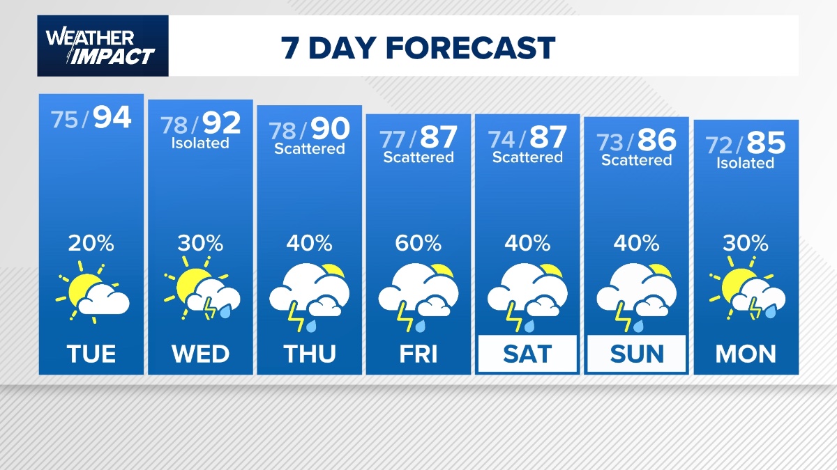 Tropical update Tropical Storm Hanna has formed in the Atlantic. Hanna is well away from the Gulf and is not a threat to Southeast Texas. Elsewhere, Fay continues to hang on over the central Atlantic. Neither system poses a threat to the Gulf, and there are no tropical concerns for Southeast Texas right now. Counties we serve Harris County (including Houston, Pasadena, Baytown), Fort Bend County (Richmond, Sugar Land, Missouri City), Montgomery County (Conroe, The Woodlands), Brazoria County (Angleton, Pearland, Alvin, Lake Jackson), Galveston County (Galveston, League City, Texas City), Liberty County (Liberty, Cleveland, Dayton), Walker County (Huntsville, New Waverly), Waller County (Hempstead, Prairie View, Waller), Polk County (Livingston, Corrigan), Chambers County (Anahuac, Mont Belvieu, Winnie), Wharton County (Wharton, El Campo), Washington County (Brenham), Matagorda County (Bay City, Palacios), Grimes County (Anderson, Navasota), Austin County (Bellville, Sealy), Colorado County (Columbus, Eagle Lake, Weimar), Trinity County (Groveton, Trinity). www.khou.com/article /weather/forecast/ho uston-weather-impact -alert-tropics/
lynnsgirl and TexasGal reacted Most places will stay hot, humid and dry. A few showers could develop southwest of Houston around midday, with isolated showers possible west of Interstate 45 during the afternoon. A rumble of thunder is possible, but widespread rain is not expected.
Forecasters are watching moisture associated with Hurricane Polo as it moves inland across northern Mexico. The storm is not expected to bring damaging winds to Houston, but its moisture could help fuel heavier rain when it interacts with a slow-moving front later in the week.
Houston and surrounding counties are currently in a lower-end excessive rainfall risk, with the greater concern west of the metro area.
Most of Southeast Texas is expected to receive about one-half inch to 1 inch of rain over several days. Some spots could pick up 1 to 3 inches.
Forecast models show widespread rainfall totals of 3 to 5 inches in parts of that region from the middle through latter part of the week. Some areas could receive 8 to 9 inches of rain.




 West-Tex

Let's see if school's start calling it today as they did last time and I enjoyed the day off but it was DRY................!
West-Tex reacted
Well, will you look at this LOCALLY WRONG AGAIN i WISH I COULD BE THIS WRONG ALL THE TIME AND KEEP MY JOB
Genesis, Luckysis and West-Tex reacted « Back to Chat
Views: 312
# Replies: 17