Don't miss what's happening in Atascocita
People on Atascocita.com are the first to know.
Go to top of page
Close
 
Close
Back

The San Jacinto West Fork at US 59 has reached a new record

The San Jacinto West Fork at US 59 has reached a new record

« Back
This discussion has been locked.
Message Menu
by: AtascocitaDotCom Active Indicator LED Icon 10 Site Admin  OP 
~ 6 years ago   Aug 29, '17 9:38am  
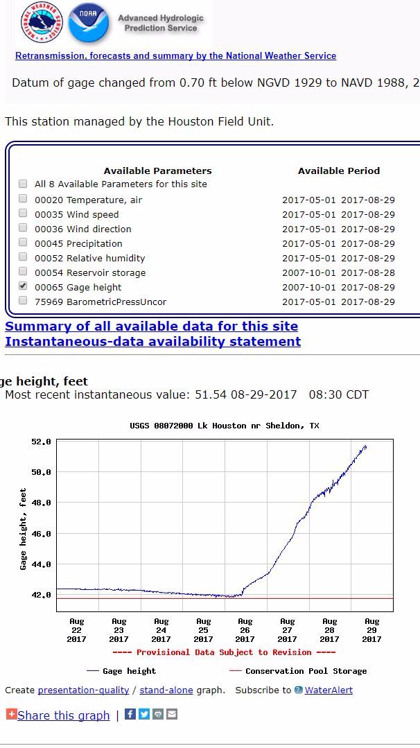
The San Jacinto West Fork at US 59 has reached a new record breaking high water level as of today, Tuesday, August 29th, 2017. US 59 is completely impassable at the San Jacinto river.
 
At 68.17 feet as of 8:45am, this is just enough to take its place in first as the highest water level ever recorded for the San Jacinto. Yes, even more than the 1994 flood. In fact, this new record surpasses all others including measures taken all the way back to the first high river water mark measured in this location back in 1929.
 
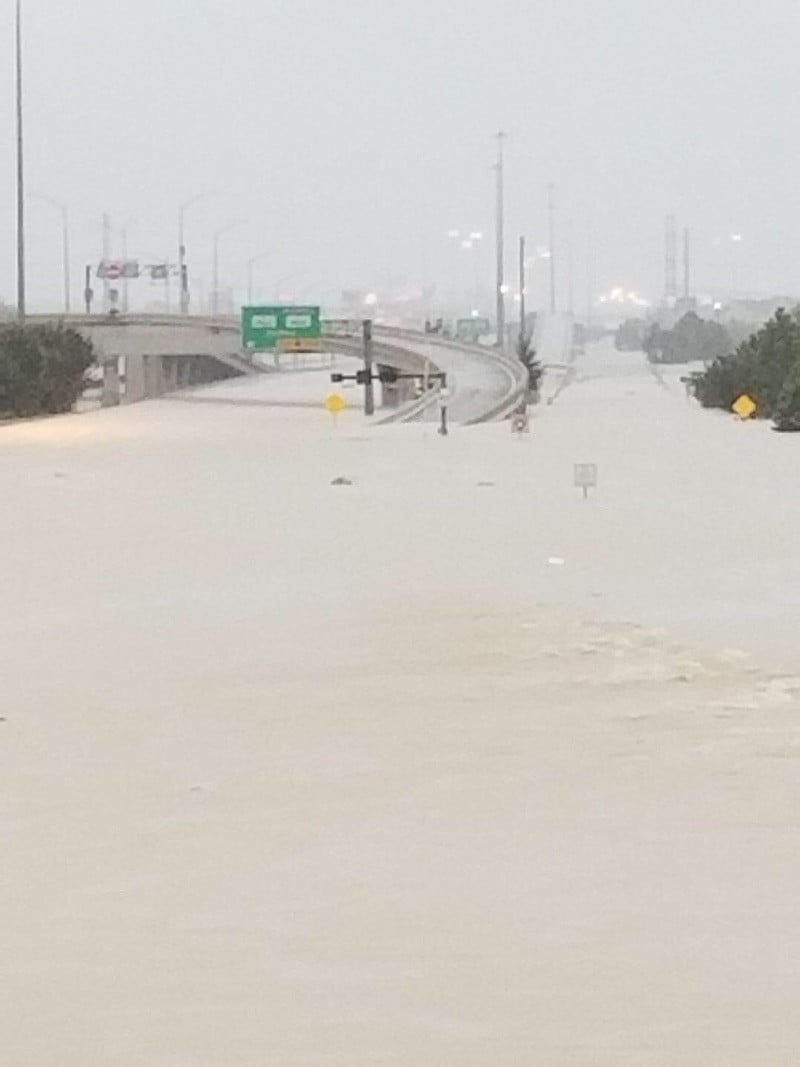
Below is a photo taken from US 59 looking in the direction of FM 1960 and the mall, just north of the San Jacinto river:
 
Loading Image...
 
h/t @Boobear
 
Loading Image...
 
Loading Image...
 
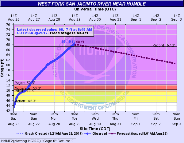
Source: National Weather Service, Advanced Hydrological Prediction Service
water.weather.gov/ah ps2/hydrograph.php?w fo=HGX&gage=HMMT2
* Reactions disabled on political threads.
What are your thoughts? Log in or sign up to comment
Replies:
Message Menu
cousindan Active Indicator LED Icon 4
~ 6 years ago   Aug 29, '17 9:40am  
And guess who is dumping water into the san jacinto. They are 2ft down since yesterday
* Reactions disabled on political threads.
Message Menu
Gami426 Active Indicator LED Icon  New Member
~ 6 years ago   Aug 29, '17 9:57am  
Any evacuations in Atascocita? I know Kingwood has had some.
* Reactions disabled on political threads.
Message Menu
analogkid Active Indicator LED Icon 3
~ 6 years ago   Aug 29, '17 10:03am  
Lake Conroe release down to 27,000 cfs; 1/3 of last night's release. Fingers crossed...
* Reactions disabled on political threads.
Message Menu
West-Tex Active Indicator LED Icon 13
~ 6 years ago   Aug 29, '17 10:12am  
That pic is crazy!
* Reactions disabled on political threads.
Message Menu
Smokeybear Active Indicator LED Icon 8 Forum Moderator
~ 6 years ago   Aug 29, '17 10:26am  
Loading Image...
 
Lake level at the dam up another 1.5 feet. Over 10 ft above spillway now. This will change the look of the river. Let's hope all the pipelines under the river hold.
* Reactions disabled on political threads.
Message Menu
cousindan Active Indicator LED Icon 4
~ 6 years ago   Aug 29, '17 10:35am  
Loading Image...
 
Loading Image...
 
this is zoomed in data from both lakes.
* Reactions disabled on political threads.
Message Menu
mzfee Active Indicator LED Icon  New Member
~ 6 years ago   Aug 29, '17 11:08am  
@Gami426 One of my family members on the other side of town said they are evacuating Kingwood and parts of Atascocita close to Kingwood. But I don't know specifics, I was hoping one of you knew.
* Reactions disabled on political threads.
Message Menu
AlettertoElise Active Indicator LED Icon 8 Forum Moderator
~ 6 years ago   Aug 29, '17 11:38am  
Unfortunately even tho Lake Conroe has slowed their release, which is certainly great news, the water from Cypress and Spring creeks is still heading our way via the San Jacinto. Stay vigilant everyone!
* Reactions disabled on political threads.
Message Menu
mzfee Active Indicator LED Icon  New Member
~ 6 years ago   Aug 29, '17 12:48pm  
aww man...we don't need any more water...everyone stay safe.
* Reactions disabled on political threads.
Message Menu
brightlights Active Indicator LED Icon 15 Forum Moderator
~ 6 years ago   Aug 29, '17 1:03pm  
Anyone know if those businesses on the west side of 59 (Pappas Seafood, Best Buy, etc.) are under water? Have a friend whose daughter works in that center and is panicking. (I know...not the biggest concern, but trying to find info for her.)
* Reactions disabled on political threads.
Message Menu
AlettertoElise Active Indicator LED Icon 8 Forum Moderator
~ 6 years ago   Aug 29, '17 1:05pm  
@brightlights, I saw a video that showed that center flooded at least to Dimassi's.....and that was taken hours ago, so it may all be flooded by now.
* Reactions disabled on political threads.
Message Menu
TXNS_fan Active Indicator LED Icon 13
~ 6 years ago   Aug 29, '17 1:10pm  
The exit onto Townsend by Party City was flooded yesterday
* Reactions disabled on political threads.
Message Menu
brightlights Active Indicator LED Icon 15 Forum Moderator
~ 6 years ago   Aug 29, '17 1:11pm  
@AlettertoElise Thanks... trying to figure out where Dimassi's is...
 
Edited: nevermind...got it. Thanks, y'all!
* Reactions disabled on political threads.
Message Menu
AlettertoElise Active Indicator LED Icon 8 Forum Moderator
~ 6 years ago   Aug 29, '17 1:18pm  
@brightlights, it's the old Zio's location. Now Dimassi's
* Reactions disabled on political threads.
Message Menu
AlettertoElise Active Indicator LED Icon 8 Forum Moderator
~ 6 years ago   Aug 29, '17 1:58pm  
Live press conference on now. Saying that San Jacinto River continues to rise. They are hopeful that it will crest sometime today or tonight, but there's no way to predict when or at what height. 😔
* Reactions disabled on political threads.
123»
This discussion has been locked.
« Back to Main Page
Views: 28,798
# Replies: 35

AFC Urgent Care Humble
 
Primrose School of Eagle Springs Logo Marshburn's Flooring America Logo K & S Sportswear Logo Wild Birds Unlimited Logo Anthony Electric Co. Logo Club Studio Logo Yard Birds, Inc. Logo Best Investments Siding & Windows Logo Sabaoth Massage Logo JMP Wines Logo Houston Custom Carpets Flooring & Remodeling Logo The Framestead Group Logo A+ Atascocita Lawn Services Logo River Rock Pools Logo Modern Heart and Vascular Institute  Logo Warren's Southern Gardens Logo Elite Hospital Kingwood Logo Aire Serv of Heating and Air Conditioning Logo
Sponsor an ad Sponsor an Ad »